SP3
Sea level and Coastal Extreme Events

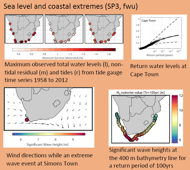
Southern Africa has about 4600 km of coastline with many big cities near the coast and a constantly increasing population concentrated there. Extreme events such as the storm surge of March 2017 are already threatening life in the coastal regions of Namibia and South Africa. Around half of the coast currently consists of flat beaches, estuaries and lagoons, which are also home to the largest cities such as Cape Town, Port Elizabeth and Durban. Extreme storm events generate waves of over eight meters, whose enormous forces lead to coastal erosion, flooding in areas without flood protection systems and failure of existing coastal protection systems. Consequently, flooding frequently occurs. At the same time, heavy rainfall events can lead to increased surface runoff and rising river water levels, which further increase the risk of flooding.
Climate change poses major challenges for this region, as rising sea levels and increased sea surface temperatures successively increase the risk of such extreme events and resulting flooding. Climate change is thus increasingly becoming a challenge for infrastructure, transport, agriculture, and water resource management in coastal areas. Despite this well-known and successive danger, neither the phenomenon of sea-level rise and associated storm surges nor their consequences along the coasts of southern Africa are sufficiently understood up to date.
The Agulhas Current system is expected to play a key role in the development of extreme events along the coast of southern Africa. The Agulhas Current is one of the most powerful ocean currents in the world, transporting warm and salty water from the tropical Indian Ocean to the south. The entire Agulhas Current system in turn depends heavily on the large-scale wind fields in the southern hemisphere. Changes in the Agulhas Current system that have already been observed and are predicted for the future lead to a warming of the surface water and thus have an impact on the climate in the countries bordering the Atlantic Ocean, especially in southern Africa. Changes in precipitation patterns and rainfall quantities play a particularly important role not only for drinking water supply and agriculture, but also the possible threat of heavy rainfall events. CASISAC simulates the effects of changes in the Agulhas Current region on the regional climate in southern Africa. Ocean currents are closely linked to sea surface patterns, whereby the global sea level rise can be regionally amplified but also compensated. In addition, there are possible changes in the distribution and heights of surface waves. CASISAC quantifies and combines all effects, like changes in precipitation levels and resulting fluvial inputs, as well as sea level rise, and waves as important parameters for a regional impact assessment for the South African coast.
The objectives of CASISAC SP3 "Sea Level and Coastal Extreme Events" in particular are a comprehensive coastal hydrological system analysis, the identification of possible climatic and anthropogenic changes, and their influence on coastal protection strategies and design issues. The overall goal is the estimation of observed and projected changes in sea level and wave climate as well as the extreme value statistical classification of storm surge events. Of particular interest is the question how changes in the southern hemispheric westerly winds and the Agulhas Current system influence the occurrence of extreme storm surges along the coast and whether such extreme storm surges may overlap with heavy rainfall and increased inland runoff in estuaries. The parameters developed in the framework of CASISAC SP3 are the basis for the modelling of socio-economic impacts of storm surges along with associated floods and are expected to contribute significantly to the development of appropriate management and protection strategies along the coasts of southern Africa.
External Link to Sub-project 3